Surveying Services
Aerial photography documentation
UAV- or UL Flights
3D Laser scanning service
3D as-built documentation
Object scanning & find documentation
High resolution 3D documentation
Data for multimedia & model building
Further processing of 3D data
Hightech 3D Surveying
ArcTron is a 3D service provider for 3D as-built documentation and creating 3D digital twins with the latest laser scanners, UAVs and combined surveying technologies! Whether landscape surveys, monuments, buildings or industrial plants, infrastructure projects, insurance or damage claims, archaeological excavations and small finds, art historical treasures or prototypes – with different sensors and with combined airborne, mobile and terrestrial 3D scanning processes, we create the right one for your project 3D digitization concept for the best possible price-performance ratio.
Digital 3D documentation: fast, precise, inexpensive
Especially when it comes to archaeological finds and museum objects, you can count on our expertise. Depending on the nature of the object or objective, the digital 3D twin is captured by means of photogrammetry, laser scanning or computed tomography. The data is then processed accordingly with the endresult being a digital/virtual 3D model in high resolution. This digital 3D-twin can also be used for 3D printing and creating physical replicas. In many projects the data is intigrated in multimedia applications or web presentations. The different specialist departments in our company (e.g. ingeneers, 3D designers, programmers, modelbuilders etc.) work together in close coordination to achieve the best possible result.
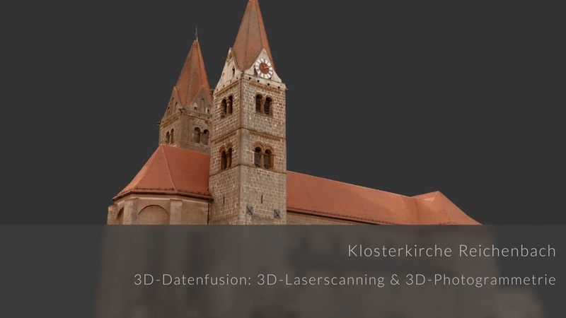
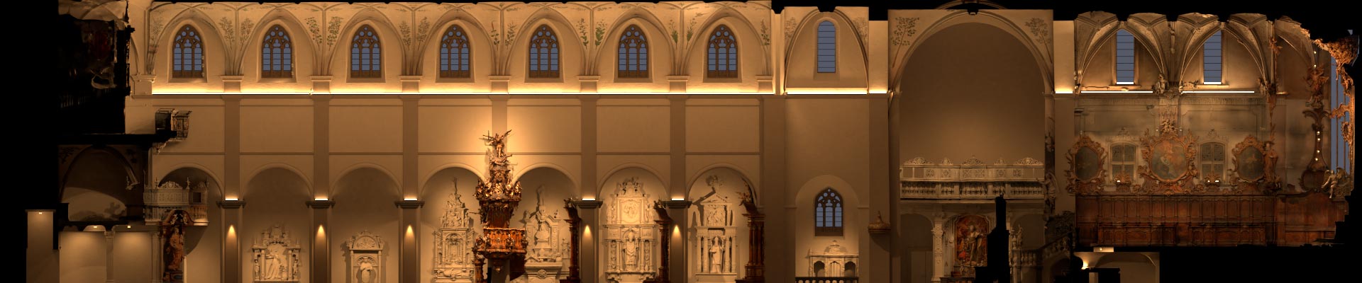
Above all, the true to shape measurement of buildings including historical or ecclesiastical objects are our speciality. We capture portals, facades, cellar vaults, staircases, historic roof trusses, interiors, roofs, the inventory of churches or entire castles – you benefit from our 30 years of experience.
The as-built 3D documentations for restoration purposed serves to provide information about the construction, materials and condition of the object. For this purpose, we have engineers, construction researchers and archaeologists in our team and we are technically up to date. Different technologies are combined according to the object in order to achieve the best possible result. With the help of this data, renovation measures must be implemented in a way that is sustainable and approves to monument regulations.
The most requested outputs are CAD plans, orthophotos, floor plans, building sections, area calculations, geometry plans and views in different levels of detail, damage mapping and of course the high-resolution 3D model – also photorealistically textured.
What is a digital (3D) twin?
A 3D digital twin is a 3D digital representation of a real object at different levels of detail or resolution.
Depending on the size and scope of the object to be virtualized (e.g. architectural complex or historical doorknob, industrial plant or mechanical engineering part), the use of surveying technologies and the desired and reasonable level of detail become apparent. After the 3D data collection (laser scanning, UAV flight, photogrammetry or with 360 degree cameras) follows the specific data processing to create a digital 3D model (virtual or digital 3D twin).
Advantages of a digital 3D twin
- represents a current actual state
- can be used for planning purposes or conversion measures
- generating 3D prints from the digital twin to reproduce a scaled, physical 3D model
- can be used e.g. for augmented reality applications or virtual reality
- can be used as 360 degree representation
Engineering 3D documentation doesn’t have to be expensive – we use workflows and technologies that enable rapid on-site surveying and targeted data processing in our office to deliver fast and accurate results, saving you money.
Our services include:
- Building interior surveys (floor plans, transverse and longitudinal sections)
- Roof surveying and damage assessment (by drone)
- Building survey as well as architectural and real estate survey (architectural plans)
- Land surveying and landscape surveying
- 3D deformation survey
We have a large technology pool at our disposal, consisting of total stations, GPS, drones, laser scanners and photogrammetry equipment.
We generate what you need: e.g. plans, sections, views, digital 3D models…
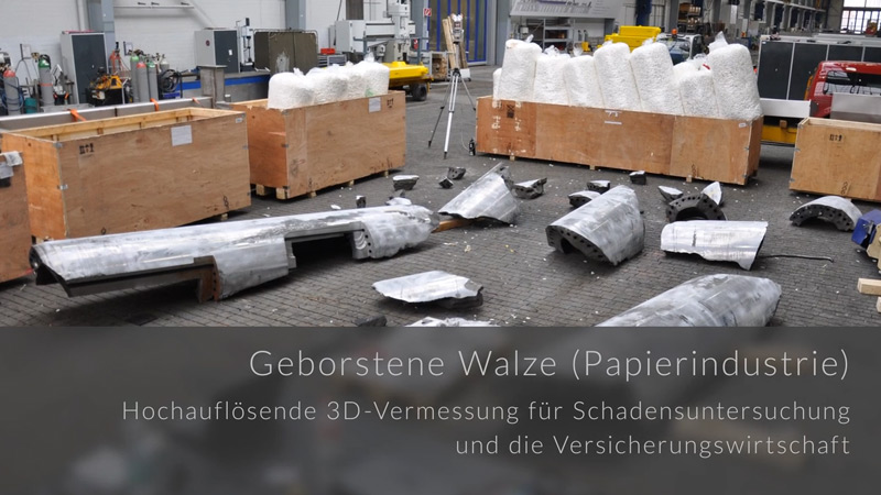
3D laser scanning is very often used for the inventory of factories and industrial plants, production halls and warehouses. The goal is often to document the plant inventory, to plan reconstruction measures or to use the 3D data for static calculations.
Damages are also documented in detail and serve as documentation of the actual condition and as preservation of evidence in order to clarify causes and cases of damage. In doing so, it is necessary to be on site quickly. Give us a call – we will advise you immediately and provide you with an attractive service offer without delay.
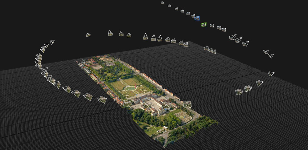
For landscape surveys we have several aircraft available – helicopters, small planes, a motorized paragliding trike and different drone models. The choice of aircraft (if necessary in combination with laser scanning) is determined by the size of the area and the scope of the survey.
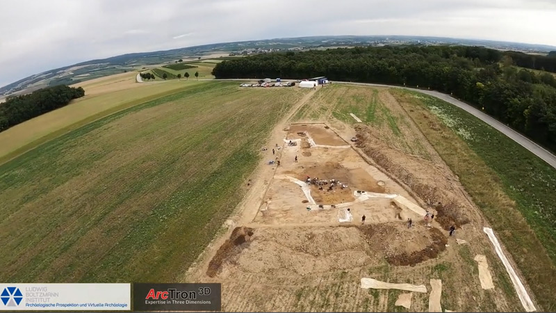
The main focus in this area is on archaeological excavation areas, installations, aerial survey of pits, tunnels, caves, mining areas and quarries, building complexes incl. surrounding landscape, historical ruins with corresponding terrain. We also perform aerial archaeology.
The objectives of such a survey include:
- fast and cost-efficient planning principles
- volume calculations in quarries and mining areas
- in cave surveys for geological classification and for general and precise recording of a cave system
- data from ruin surveys serve as a precise basis for digital building or phase reconstruction
- specifying location of archaeological sites through airborne surveys
- three-dimensional inventory of excavation areas
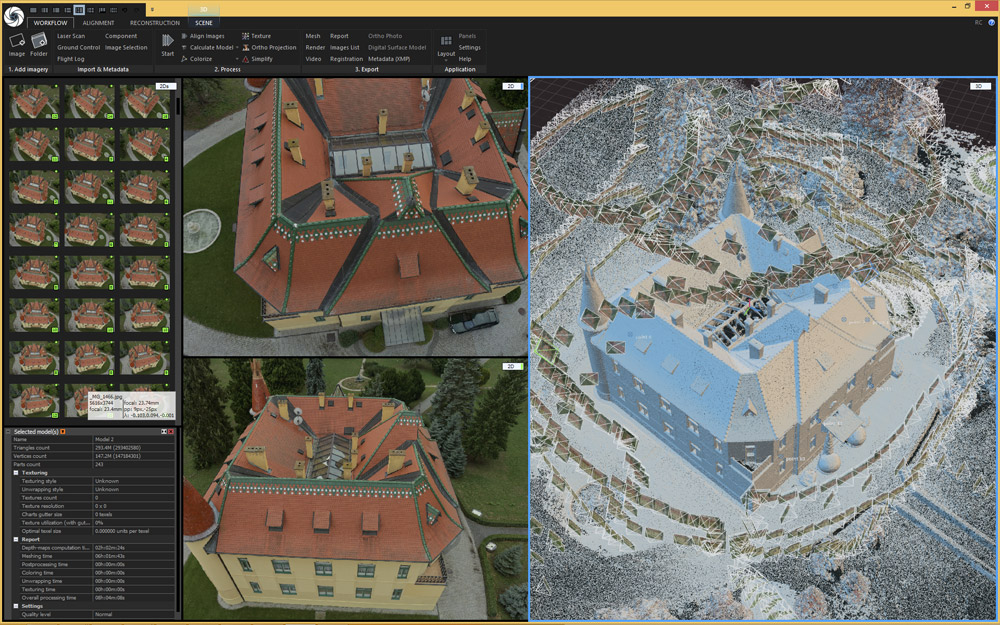
Example of a fast and cost-effective 3D object measurement (here in reduced resolution). Click here for the 3D measurement reference page Rammenau Castle
(Further) processing of 3D survey data
From the comprehensively and completely determined 3D as-built surveys, we derive metrologically precise, multifaceted results: 3D point clouds as raw data, architect-ready CAD plans or 3D BIM objects, orthophotos, floor plans, sections, damage mapping, high-resolution photorealistic 3D models, multimedia media productions with 3D animations, modeled “3D worlds” for real-time and simulation platforms, augmented reality or real haptic models with 3D printing and CNC milling technologies.
The 3D inventory and 3D measurement with combined high-tech sensors. With a dedicated team of more than 20 3D specialists, we are ready for your task!
As experts in 3D process chains, we can refer to more than 1,500 successful 3D projects since 2001, including major projects in more than 50 UNESCO World Heritage sites.
Our customers include the industry- as well as the insurance sector, architecs, ecclesiastical institutions, research institutes and universities, state departments, municipal authorities and museums.
Our professional specialties are complex industrial 3D as-built surveys and the documentation of architectural, artistic, ecclesiastical and cultural monuments as well as 3D documentation in archaeology and restoration sciences.
Allow us to present our expertise to serve you!
How and what is measured using 3D laser scanning?
With millimeter-precise, high-quality terrestrial 3D laser scanners (e.g. Riegl, Leica Geosystems, Surphaser et al.) often combined with further 3D technologies (e.g. hand-held structured light scanners and photogrammetry), we capture objects of various types and sizes – naturally in 3D. Digitisation is carried out according to your respective accuracy requirements and photorealistically with the respective real colors (RGB) of the object surfaces – quickly and efficiently.

We are specialized primarily in 3D surveying of historical buildings, facades and ruins, of castles, palaces, ecclesiastical buildings or complex geometries like rock formation etc. But we also carry out conventional modern industrial and architectural surveying. For fast and cost-effective 3D surveying, we combine high-tech surveying methods such as terrestrial and mobile 3D laser scanning, photogrammetry and UAV flight.
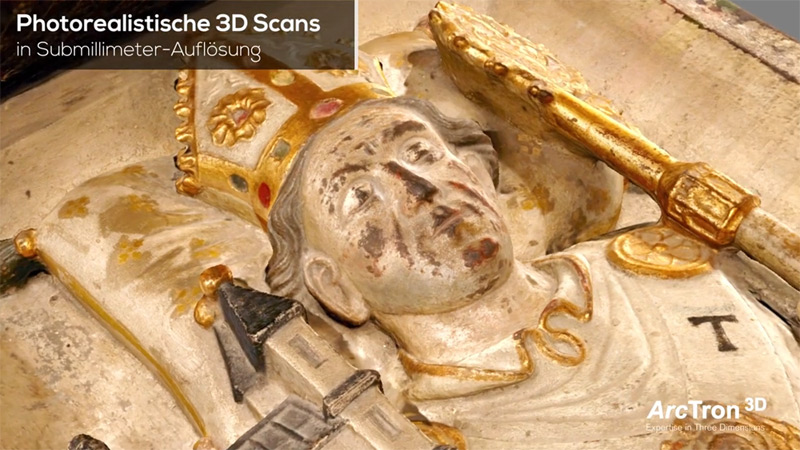
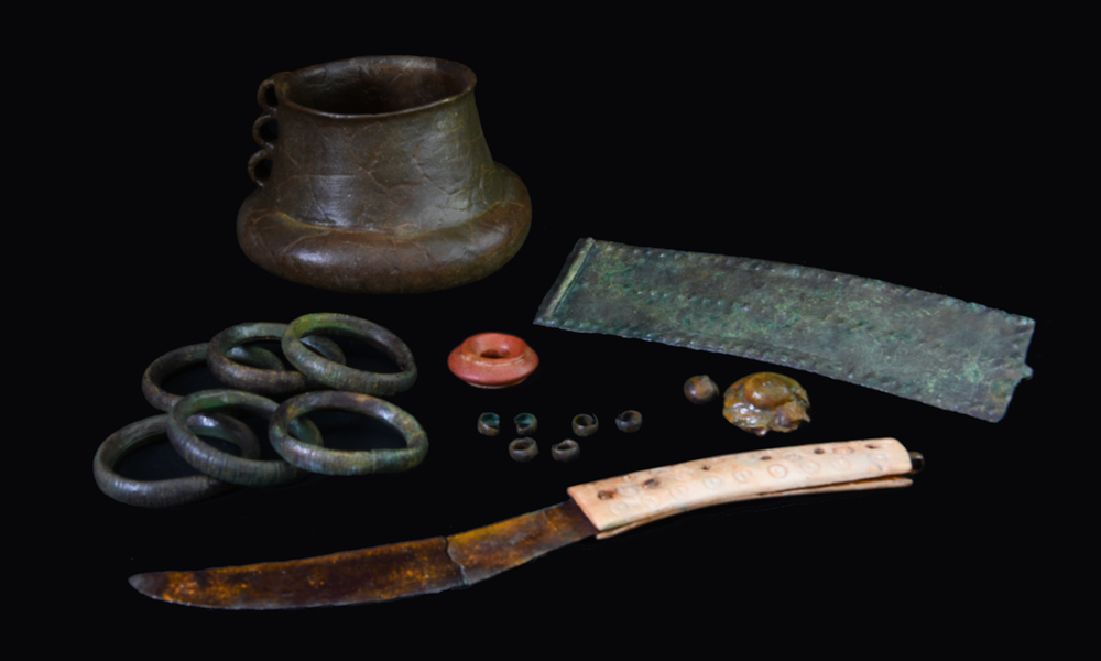
When documenting small objects with accuracy requirements deep in the sub-millimeter range using light projection systems, hand-held 3D scanners often combined with macro-photogrammetry or by means of computed tomography (CT), this is when we use high-res object scanning. We specialize in coins, archaeological finds, artifacts and museum objects of all kinds. Especially for difficult surfaces such combined systems offer best results! Thus, we create the data basis for extremely accurate and photorealistic 3D models.
3D measurement of museum objects with data preparation – also for multimedia presentation or replica production.
Example picture on the right: The objects have been scanned and the data printed in 3D. In the final step our art painter is coloring the replicas true to the original.
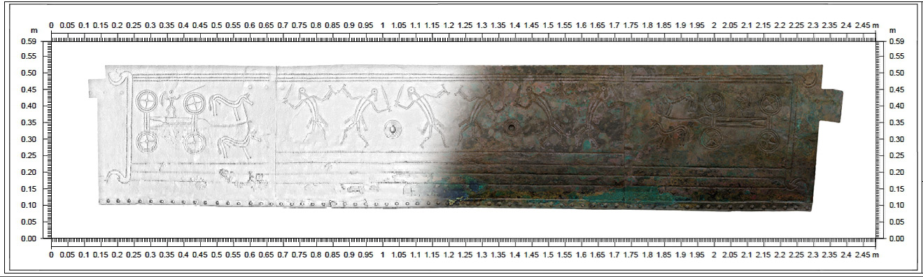
What is short-range and macro photogrammetry?
The documentation takes place within the very close macro range with special lenses and professional studio equipment. Depending on the requirements, we document with high dynamic range (HDR) and create razor-sharp macros with focus stacking methods. We also offer suitable solutions for complex and highly reflective surfaces.
Depending on the task, we document objects of almost any size and shape using high-quality cameras and photogrammetric software technologies, such as the “structure from motion” (SfM) method.
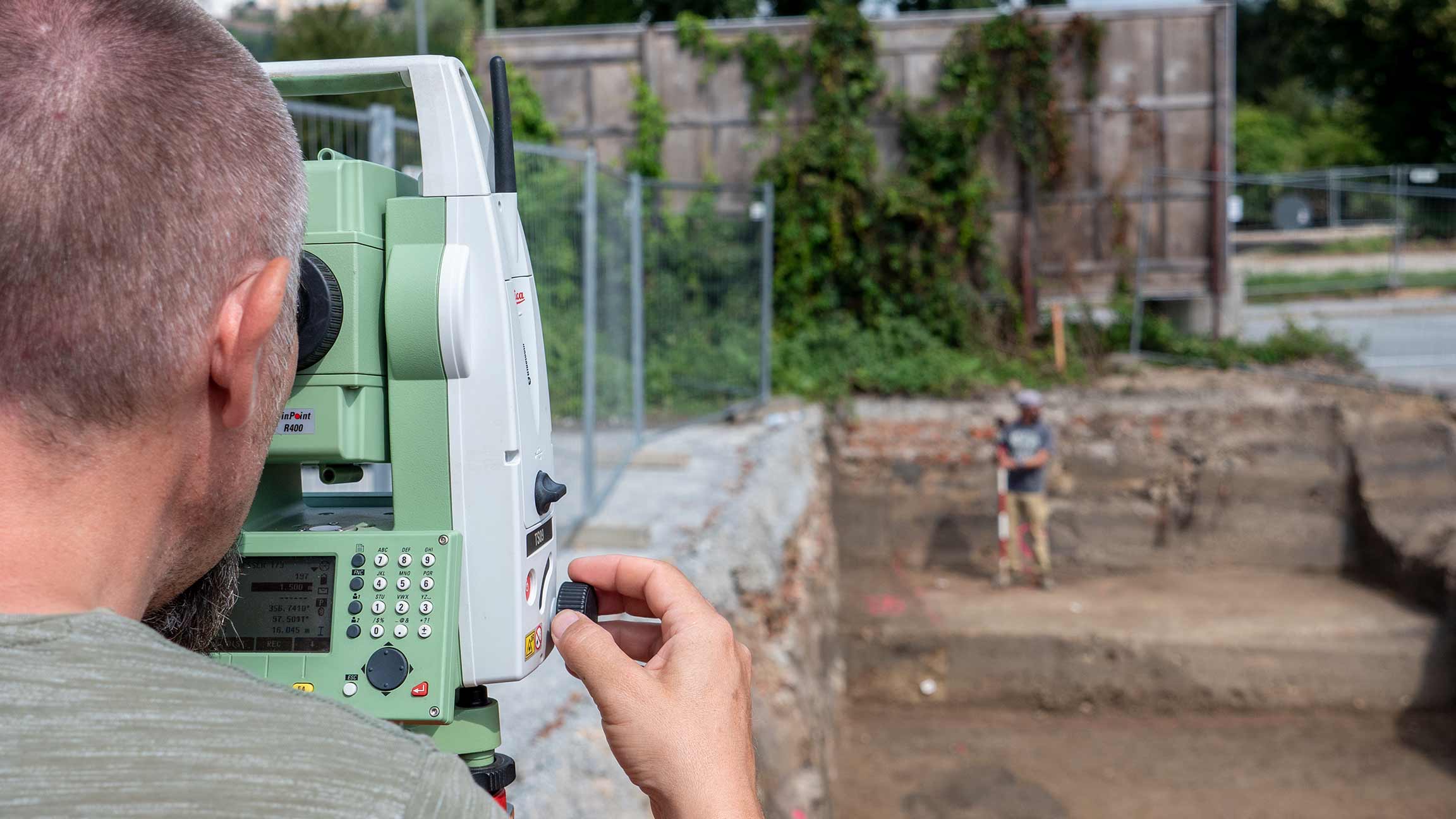
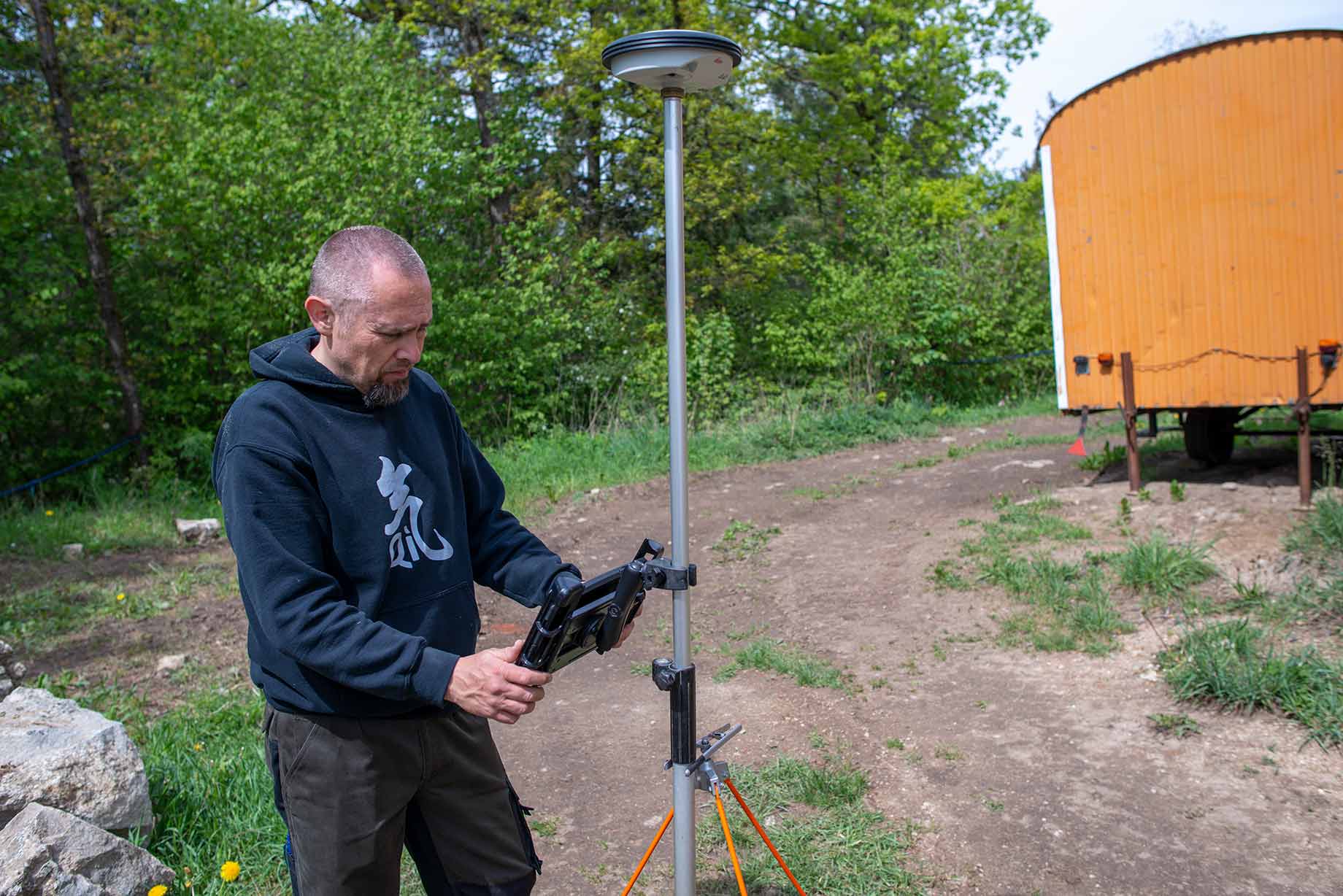
For documentation and basic surveying of monument preservation, architecture or archaeological excavations, we have been not only offering the service but also selling total stations and GPS systems (Leica Geosystems) for years. With our software solutions you generate automated plans directly from the total station and use your own smartphone or tablet to convert the incoming data in real time into a GIS & CAD compatible plan.
Terrain models, forest areas, infrastructure projects, industrial facilities or architectural ensembles can be captured most effectively from the air using airborne laser scanning and/or photogrammetric aerial imagery.
Airborne laser scanning can be used to filter vegetation so that accurate digital terrain models can be calculated without vegetation or buildings. We also offer aerial archaeology.
Depending on the size of the area and the desired resolution, the survey can be carried out by airplane, helicopter or, at low cost, with our ultralight aircraft (motorized ultralight paraglider) or photogrammetry drones (UAVs).
We document your survey area quickly, in its entirety and with high resolution. With our solutions, we achieve very high point densities per square meter (>100 laser readings), making even the information “hidden” under the vegetation precisely visible.